array:2 [
"RF Cache Key: 27324ff3db7096e758f95cb3ff002f1de8426b69bf57e68e05d3653853b78b02" => array:1 [
"RF Cached Response" => Realtyna\MlsOnTheFly\Components\CloudPost\SubComponents\RFClient\SDK\RF\RFResponse {#3260
+items: array:1 [
0 => Realtyna\MlsOnTheFly\Components\CloudPost\SubComponents\RFClient\SDK\RF\Entities\RFProperty {#3230
+post_id: ? mixed
+post_author: ? mixed
+"ListingKey": "HMS48732033"
+"ListingId": "2546498"
+"PropertyType": "Land"
+"PropertySubType": "Unimproved Land"
+"StandardStatus": "Active"
+"ModificationTimestamp": "2026-02-10T17:32:10Z"
+"RFModificationTimestamp": "2026-02-10T17:32:46Z"
+"ListPrice": 349900.0
+"BathroomsTotalInteger": 0
+"BathroomsHalf": 0
+"BedroomsTotal": 0
+"LotSizeArea": 1.74
+"LivingArea": 0
+"BuildingAreaTotal": 0
+"City": "Kearney"
+"PostalCode": "64060"
+"UnparsedAddress": "102 W Lawrence Street, Kearney, Missouri 64060"
+"Coordinates": array:2 [
0 => -94.362626
1 => 39.376209
]
+"Latitude": 39.376209
+"Longitude": -94.362626
+"YearBuilt": 0
+"InternetAddressDisplayYN": true
+"FeedTypes": "IDX"
+"ListAgentFullName": "The Small Team"
+"ListOfficeName": "Reece Nichols-KCN"
+"ListAgentMlsId": "SMALLTEAM"
+"ListOfficeMlsId": "RAN_17"
+"OriginatingSystemName": "HMLS"
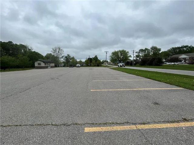
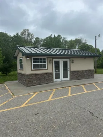
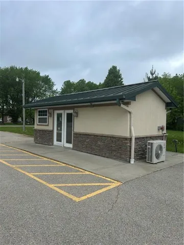
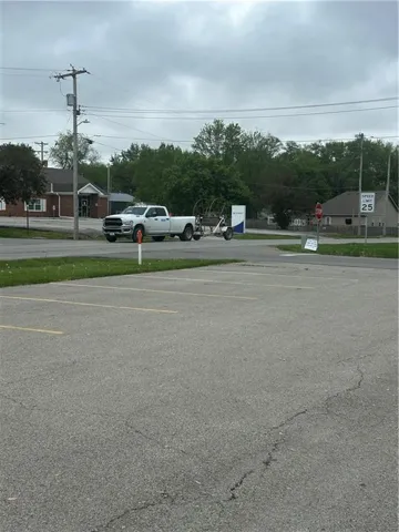
+"PublicRemarks": """
Prime commercial property with frontage on high traffic 33 Hwy in downtown Kearney. Easy access to MO 92 and I-35. \r\n
\r\n
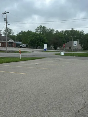
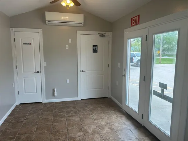
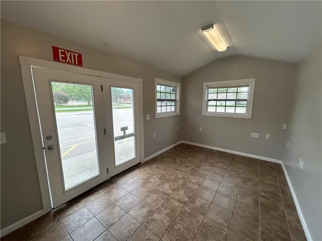
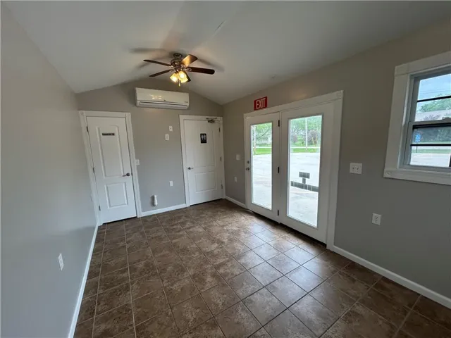
Property offers 1.74 acres +/-, an existing paved parking lot for ~20 vehicles, plus a building with power, water, sewer and can be used by the new owner for their business office. Includes an accessible bathroom and open work area. Parking area accessible from 33 Hwy or W. Lawrence. Possible uses could include food service, retail, or office.\r\n
\r\n
All utilities on site - single and three phase power in place, gas service available, 8" new city water and sewer lines on Lawrence Street. Flat terrain with a slight slope to the north. Lot is surrounded by trees.\r\n
\r\n
Kearney recently enacted a new K-353 Tax Abatement program that includes this parcel if you prefer to develop the property into its full potential. The City of Kearney is open to development plans or rezoning to residential/multi-family or other commercial uses on the site (currently zoned C-1). \r\n
\r\n
New multifamily development proposed in the area that will help support your new business location.
"""
+"ActivationDate": "2025-04-29"
+"AssociationFeeFrequency": "None"
+"AttributionContact": "816-407-5224"
+"CoListAgentFullName": "Charles Small"
+"CoListAgentKey": "1046547"
+"CoListAgentMlsId": "SMALLC"
+"CoListOfficeKey": "1008257"
+"CoListOfficeMlsId": "RAN_17"
+"CoListOfficeName": "Reece Nichols-KCN"
+"CoListOfficePhone": "816-468-8555"
+"CountyOrParish": "Clay"
+"CreationDate": "2025-04-29T20:02:13.533095+00:00"
+"CurrentUse": array:1 [
0 => "Commercial"
]
+"DevelopmentStatus": array:1 [
0 => "Finished Lot(s)"
]
+"Directions": "I035 to 92 Hwy - east to Jefferson St (33 hwy) - north to property on the left at corner of Lawrence and Jefferson."
+"HighSchoolDistrict": "Kearney"
+"RFTransactionType": "For Sale"
+"InternetEntireListingDisplayYN": true
+"ListAgentDirectPhone": "816-407-5224"
+"ListAgentKey": "1078430"
+"ListOfficeKey": "1008257"
+"ListOfficePhone": "816-468-8555"
+"ListingAgreement": "Exclusive Right To Sell"
+"ListingContractDate": "2025-04-29"
+"ListingTerms": array:2 [
0 => "Cash"
1 => "Conventional"
]
+"LotFeatures": array:1 [
0 => "City Limits"
]
+"LotSizeSquareFeet": 75794.4
+"MLSAreaMajor": "109 - East of I-35 & North of Hwy 92"
+"MlgCanUse": array:1 [
0 => "IDX"
]
+"MlgCanView": true
+"MlsStatus": "Active"
+"OtherStructures": array:1 [
0 => "Shed(s)"
]
+"ParcelNumber": "07-808-00-02-019.00"
+"PhotosChangeTimestamp": "2025-04-30T18:14:10Z"
+"PhotosCount": 17
+"PossibleUse": array:1 [
0 => "Commercial"
]
+"RoadFrontageType": array:1 [
0 => "City Street"
]
+"RoadResponsibility": array:1 [
0 => "Public Maintenance"
]
+"RoadSurfaceType": array:2 [
0 => "Asphalt"
1 => "Paved"
]
+"Sewer": array:1 [
0 => "Public Sewer"
]
+"StateOrProvince": "MO"
+"StreetDirPrefix": "W"
+"StreetName": "Lawrence"
+"StreetNumber": "102"
+"StreetSuffix": "Street"
+"SubdivisionName": "Kearney Original Town"
+"TaxLegalDescription": """
Legal Description: TRACT I: A rectangular parcel of land being 153 feet more or less from North to South an 94 feet from East to West in the Southeast corner of Lot 3, Block 16, ORIGINAL TOWN OF KEARNEY, Clay County, Missouri, according to the recorded plat thereof.\r\n
TRACT II: Lots 2 and 3, Block 16, ORIGINAL TOWN OF KEARNEY, Clay county, Missouri, EXCEPT that part conveyed to Kearney Real Estate Center, Inc., in Document No. D71490 in Book 1312 at Page 712 filed with the Clay County Recorder of Deeds of June 30, 1978.
"""
+"Topography": "Level"
+"Utilities": array:2 [
0 => "Electric to Site"
1 => "Natural Gas Available"
]
+"Vegetation": array:1 [
0 => "Cleared"
]
+"WaterSource": array:1 [
0 => "Public"
]
+"Zoning": "C"
+"HMS_Crops": "None"
+"HMS_SaleOptions": "Complete Parcel"
+"HMS_InFloodPlain": "Unknown"
+"HMS_Restrictions": "Subject To Zoning"
+"HMS_TaxTotalAmount": "3840"
+"HMS_BathroomsTotalDecimal": "0.00"
+"HMS_MaintenanceProvidedYN": "0"
+"@odata.id": "https://api.realtyfeed.com/reso/odata/Property('HMS48732033')"
+"provider_name": "HMLS"
+"Media": array:17 [
0 => array:12 [
"Order" => 0
"MediaKey" => "6812684ab2c98d74ba5fd9b4"
"MediaURL" => "https://cdn.realtyfeed.com/cdn/41/HMS48732033/0135b9e5f7028faf3a6e538e335eec8d.webp"
"MediaSize" => 114701
"MediaType" => "webp"
"Thumbnail" => "https://cdn.realtyfeed.com/cdn/41/HMS48732033/thumbnail-0135b9e5f7028faf3a6e538e335eec8d.webp"
"ImageWidth" => 576
"ImageHeight" => 768
"LongDescription" => "Land for development - looking south to Lawrence"
"ResourceRecordKey" => "HMS48732033"
"ImageSizeDescription" => "576x768"
"MediaModificationTimestamp" => "2025-04-30T18:13:30.415Z"
]
1 => array:12 [
"Order" => 1
"MediaKey" => "6812684ab2c98d74ba5fd9b5"
"MediaURL" => "https://cdn.realtyfeed.com/cdn/41/HMS48732033/c5c3bdab663c53352f146ce40a01ade9.webp"
"MediaSize" => 113845
"MediaType" => "webp"
"Thumbnail" => "https://cdn.realtyfeed.com/cdn/41/HMS48732033/thumbnail-c5c3bdab663c53352f146ce40a01ade9.webp"
"ImageWidth" => 576
"ImageHeight" => 768
"LongDescription" => "Land for development - looking north."
"ResourceRecordKey" => "HMS48732033"
"ImageSizeDescription" => "576x768"
"MediaModificationTimestamp" => "2025-04-30T18:13:30.303Z"
]
2 => array:12 [
"Order" => 2
"MediaKey" => "6812684ab2c98d74ba5fd9b6"
"MediaURL" => "https://cdn.realtyfeed.com/cdn/41/HMS48732033/b5ee44e9baa6931cbf2088f9d81482af.webp"
"MediaSize" => 167637
"MediaType" => "webp"
"Thumbnail" => "https://cdn.realtyfeed.com/cdn/41/HMS48732033/thumbnail-b5ee44e9baa6931cbf2088f9d81482af.webp"
"ImageWidth" => 1024
"ImageHeight" => 768
"LongDescription" => "View to Jefferson (33 Hwy)"
"ResourceRecordKey" => "HMS48732033"
"ImageSizeDescription" => "1024x768"
"MediaModificationTimestamp" => "2025-04-30T18:13:30.274Z"
]
3 => array:11 [
"Order" => 3
"MediaKey" => "6812684ab2c98d74ba5fd9b7"
"MediaURL" => "https://cdn.realtyfeed.com/cdn/41/HMS48732033/01114b75aadc979178e184a7df8c6577.webp"
"MediaSize" => 159244
"MediaType" => "webp"
"Thumbnail" => "https://cdn.realtyfeed.com/cdn/41/HMS48732033/thumbnail-01114b75aadc979178e184a7df8c6577.webp"
"ImageWidth" => 1024
"ImageHeight" => 768
"ResourceRecordKey" => "HMS48732033"
"ImageSizeDescription" => "1024x768"
"MediaModificationTimestamp" => "2025-04-30T18:13:30.304Z"
]
4 => array:12 [
"Order" => 4
"MediaKey" => "6812684ab2c98d74ba5fd9b8"
"MediaURL" => "https://cdn.realtyfeed.com/cdn/41/HMS48732033/e1624c68044b9f6b73b02cf4357168b4.webp"
"MediaSize" => 170973
"MediaType" => "webp"
"Thumbnail" => "https://cdn.realtyfeed.com/cdn/41/HMS48732033/thumbnail-e1624c68044b9f6b73b02cf4357168b4.webp"
"ImageWidth" => 1024
"ImageHeight" => 768
"LongDescription" => "South of building/parking along Jefferson"
"ResourceRecordKey" => "HMS48732033"
"ImageSizeDescription" => "1024x768"
"MediaModificationTimestamp" => "2025-04-30T18:13:30.288Z"
]
5 => array:12 [
"Order" => 5
"MediaKey" => "6812684ab2c98d74ba5fd9b9"
"MediaURL" => "https://cdn.realtyfeed.com/cdn/41/HMS48732033/20ced66c1222e7d0693a235ebda0d76c.webp"
"MediaSize" => 98558
"MediaType" => "webp"
"Thumbnail" => "https://cdn.realtyfeed.com/cdn/41/HMS48732033/thumbnail-20ced66c1222e7d0693a235ebda0d76c.webp"
"ImageWidth" => 576
"ImageHeight" => 768
"LongDescription" => "Looking south to vacant land."
"ResourceRecordKey" => "HMS48732033"
"ImageSizeDescription" => "576x768"
"MediaModificationTimestamp" => "2025-04-30T18:13:30.286Z"
]
6 => array:11 [
"Order" => 6
"MediaKey" => "6812684ab2c98d74ba5fd9ba"
"MediaURL" => "https://cdn.realtyfeed.com/cdn/41/HMS48732033/dd7e47d5691ff68d662a43e8474277ad.webp"
"MediaSize" => 91338
"MediaType" => "webp"
"Thumbnail" => "https://cdn.realtyfeed.com/cdn/41/HMS48732033/thumbnail-dd7e47d5691ff68d662a43e8474277ad.webp"
"ImageWidth" => 576
"ImageHeight" => 768
"ResourceRecordKey" => "HMS48732033"
"ImageSizeDescription" => "576x768"
"MediaModificationTimestamp" => "2025-04-30T18:13:30.250Z"
]
7 => array:11 [
"Order" => 7
"MediaKey" => "6812684ab2c98d74ba5fd9bb"
"MediaURL" => "https://cdn.realtyfeed.com/cdn/41/HMS48732033/e99f8f0f5aff015b4be3fa7c99db7798.webp"
"MediaSize" => 172363
"MediaType" => "webp"
"Thumbnail" => "https://cdn.realtyfeed.com/cdn/41/HMS48732033/thumbnail-e99f8f0f5aff015b4be3fa7c99db7798.webp"
"ImageWidth" => 1024
"ImageHeight" => 768
"ResourceRecordKey" => "HMS48732033"
"ImageSizeDescription" => "1024x768"
"MediaModificationTimestamp" => "2025-04-30T18:13:30.293Z"
]
8 => array:11 [
"Order" => 8
"MediaKey" => "6812684ab2c98d74ba5fd9bc"
"MediaURL" => "https://cdn.realtyfeed.com/cdn/41/HMS48732033/69afae6509fbd020ad0633d21fbc08b7.webp"
"MediaSize" => 86496
"MediaType" => "webp"
"Thumbnail" => "https://cdn.realtyfeed.com/cdn/41/HMS48732033/thumbnail-69afae6509fbd020ad0633d21fbc08b7.webp"
"ImageWidth" => 576
"ImageHeight" => 768
"ResourceRecordKey" => "HMS48732033"
"ImageSizeDescription" => "576x768"
"MediaModificationTimestamp" => "2025-04-30T18:13:30.254Z"
]
9 => array:11 [
"Order" => 9
"MediaKey" => "6812684ab2c98d74ba5fd9bd"
"MediaURL" => "https://cdn.realtyfeed.com/cdn/41/HMS48732033/2a03b30079259151408c4a95ce6eaec2.webp"
"MediaSize" => 84384
"MediaType" => "webp"
"Thumbnail" => "https://cdn.realtyfeed.com/cdn/41/HMS48732033/thumbnail-2a03b30079259151408c4a95ce6eaec2.webp"
"ImageWidth" => 576
"ImageHeight" => 768
"ResourceRecordKey" => "HMS48732033"
"ImageSizeDescription" => "576x768"
"MediaModificationTimestamp" => "2025-04-30T18:13:30.246Z"
]
10 => array:11 [
"Order" => 10
"MediaKey" => "6812684ab2c98d74ba5fd9be"
"MediaURL" => "https://cdn.realtyfeed.com/cdn/41/HMS48732033/fc1602c013e7ee580161f7ac81cb8c5f.webp"
"MediaSize" => 85855
"MediaType" => "webp"
"Thumbnail" => "https://cdn.realtyfeed.com/cdn/41/HMS48732033/thumbnail-fc1602c013e7ee580161f7ac81cb8c5f.webp"
"ImageWidth" => 576
"ImageHeight" => 768
"ResourceRecordKey" => "HMS48732033"
"ImageSizeDescription" => "576x768"
"MediaModificationTimestamp" => "2025-04-30T18:13:30.305Z"
]
11 => array:12 [
"Order" => 11
"MediaKey" => "6812684ab2c98d74ba5fd9bf"
"MediaURL" => "https://cdn.realtyfeed.com/cdn/41/HMS48732033/ed0c1273ec85149b35741aa7fcfaa658.webp"
"MediaSize" => 146211
"MediaType" => "webp"
"Thumbnail" => "https://cdn.realtyfeed.com/cdn/41/HMS48732033/thumbnail-ed0c1273ec85149b35741aa7fcfaa658.webp"
"ImageWidth" => 1024
"ImageHeight" => 768
"LongDescription" => "Parking lot for new building"
"ResourceRecordKey" => "HMS48732033"
"ImageSizeDescription" => "1024x768"
"MediaModificationTimestamp" => "2025-04-30T18:13:30.319Z"
]
12 => array:11 [
"Order" => 12
"MediaKey" => "6812684ab2c98d74ba5fd9c0"
"MediaURL" => "https://cdn.realtyfeed.com/cdn/41/HMS48732033/8f75a5811fc8f7acf78beaf9bf594b82.webp"
"MediaSize" => 91876
"MediaType" => "webp"
"Thumbnail" => "https://cdn.realtyfeed.com/cdn/41/HMS48732033/thumbnail-8f75a5811fc8f7acf78beaf9bf594b82.webp"
"ImageWidth" => 1024
"ImageHeight" => 768
"ResourceRecordKey" => "HMS48732033"
"ImageSizeDescription" => "1024x768"
"MediaModificationTimestamp" => "2025-04-30T18:13:30.344Z"
]
13 => array:11 [
"Order" => 13
"MediaKey" => "6812684ab2c98d74ba5fd9c1"
"MediaURL" => "https://cdn.realtyfeed.com/cdn/41/HMS48732033/5df5933cd053fae8987b8798f1b05bd3.webp"
"MediaSize" => 92489
"MediaType" => "webp"
"Thumbnail" => "https://cdn.realtyfeed.com/cdn/41/HMS48732033/thumbnail-5df5933cd053fae8987b8798f1b05bd3.webp"
"ImageWidth" => 1024
"ImageHeight" => 768
"ResourceRecordKey" => "HMS48732033"
"ImageSizeDescription" => "1024x768"
"MediaModificationTimestamp" => "2025-04-30T18:13:30.238Z"
]
14 => array:11 [
"Order" => 14
"MediaKey" => "6812684ab2c98d74ba5fd9c2"
"MediaURL" => "https://cdn.realtyfeed.com/cdn/41/HMS48732033/9d2497112b2264f4c656ae1b92d0e8c6.webp"
"MediaSize" => 87078
"MediaType" => "webp"
"Thumbnail" => "https://cdn.realtyfeed.com/cdn/41/HMS48732033/thumbnail-9d2497112b2264f4c656ae1b92d0e8c6.webp"
"ImageWidth" => 1024
"ImageHeight" => 768
"ResourceRecordKey" => "HMS48732033"
"ImageSizeDescription" => "1024x768"
"MediaModificationTimestamp" => "2025-04-30T18:13:30.312Z"
]
15 => array:11 [
"Order" => 15
"MediaKey" => "6812684ab2c98d74ba5fd9c3"
"MediaURL" => "https://cdn.realtyfeed.com/cdn/41/HMS48732033/1615ab6de143ed1bd04ffd8c83006332.webp"
"MediaSize" => 56459
"MediaType" => "webp"
"Thumbnail" => "https://cdn.realtyfeed.com/cdn/41/HMS48732033/thumbnail-1615ab6de143ed1bd04ffd8c83006332.webp"
"ImageWidth" => 576
"ImageHeight" => 768
"ResourceRecordKey" => "HMS48732033"
"ImageSizeDescription" => "576x768"
"MediaModificationTimestamp" => "2025-04-30T18:13:30.282Z"
]
16 => array:12 [
"Order" => 16
"MediaKey" => "6812684ab2c98d74ba5fd9c4"
"MediaURL" => "https://cdn.realtyfeed.com/cdn/41/HMS48732033/039f68300f76909a28aa32c7bc04e4ae.webp"
"MediaSize" => 55760
"MediaType" => "webp"
"Thumbnail" => "https://cdn.realtyfeed.com/cdn/41/HMS48732033/thumbnail-039f68300f76909a28aa32c7bc04e4ae.webp"
"ImageWidth" => 576
"ImageHeight" => 768
"LongDescription" => "200 Amp panel in building"
"ResourceRecordKey" => "HMS48732033"
"ImageSizeDescription" => "576x768"
"MediaModificationTimestamp" => "2025-04-30T18:13:30.276Z"
]
]
}
]
+success: true
+page_size: 1
+page_count: 1
+count: 1
+after_key: ""
}
]
"RF Query: /Property?$select=ALL&$orderby=ModificationTimestamp DESC&$top=4&$filter=PropertyType in ('Land', 'Residential') AND PropertySubType eq 'Unimproved Land'/Property?$select=ALL&$orderby=ModificationTimestamp DESC&$top=4&$filter=PropertyType in ('Land', 'Residential') AND PropertySubType eq 'Unimproved Land'&$expand=Media/Property?$select=ALL&$orderby=ModificationTimestamp DESC&$top=4&$filter=PropertyType in ('Land', 'Residential') AND PropertySubType eq 'Unimproved Land'/Property?$select=ALL&$orderby=ModificationTimestamp DESC&$top=4&$filter=PropertyType in ('Land', 'Residential') AND PropertySubType eq 'Unimproved Land'&$expand=Media&$count=true" => array:2 [
"RF Response" => Realtyna\MlsOnTheFly\Components\CloudPost\SubComponents\RFClient\SDK\RF\RFResponse {#3910
+items: array:4 [
0 => Realtyna\MlsOnTheFly\Components\CloudPost\SubComponents\RFClient\SDK\RF\Entities\RFProperty {#3913
+post_id: "244434"
+post_author: 1
+"ListingKey": "HMS51280962"
+"ListingId": "2601080"
+"PropertyType": "Land"
+"PropertySubType": "Unimproved Land"
+"StandardStatus": "Active"
+"ModificationTimestamp": "2026-02-10T18:38:10Z"
+"RFModificationTimestamp": "2026-02-10T18:40:15Z"
+"ListPrice": 4000.0
+"BathroomsTotalInteger": 0
+"BathroomsHalf": 0
+"BedroomsTotal": 0
+"LotSizeArea": 0.21
+"LivingArea": 0
+"BuildingAreaTotal": 0
+"City": "Mound City"
+"PostalCode": "66056"
+"UnparsedAddress": "18 Locust Lane, Mound City, Kansas 66056"
+"Coordinates": array:2 [
0 => -94.793591
1 => 38.116344
]
+"Latitude": 38.116344
+"Longitude": -94.793591
+"YearBuilt": 0
+"InternetAddressDisplayYN": true
+"FeedTypes": "IDX"
+"ListAgentFullName": "Scott Theis"
+"ListOfficeName": "Stutesman's Action Realty"
+"ListAgentMlsId": "511000320"
+"ListOfficeMlsId": "STUTE"
+"OriginatingSystemName": "HMLS"
+"PublicRemarks": "This 70x130 lot is an open canvas for your lake lot!"
+"ActivationDate": "2026-02-10"
+"AssociationFee": "218"
+"AssociationFeeFrequency": "Annually"
+"AssociationYN": true
+"AttributionContact": "417-321-0929"
+"CountyOrParish": "Linn, KS"
+"CreationDate": "2026-02-10T18:39:49.066914+00:00"
+"CurrentUse": array:1 [
0 => "Recreational"
]
+"DevelopmentStatus": array:2 [
0 => "Raw Land"
1 => "See Remarks"
]
+"Directions": "Take Hwy 7 to Blackberry Dr and turn East. Follow Blackberry Drive and turn East onto Sycamore Dr at the T. Follow as it becomes Sugar Lake Dr and continue on. Turn left at Walnut Dr and follow to Pine Dr. Turn right and follow to where the V becomes Willow Ln. Turn right at Walnut Ln, and the lot is immediately to the left."
+"ElementarySchool": "Jay Hawk Linn"
+"HighSchool": "Jay Hawk Linn"
+"HighSchoolDistrict": "Jay Hawk Linn"
+"RFTransactionType": "For Sale"
+"InternetEntireListingDisplayYN": true
+"ListAgentDirectPhone": "417-321-0929"
+"ListAgentKey": "1071106"
+"ListOfficeKey": "1008751"
+"ListOfficePhone": "417-667-8400"
+"ListingAgreement": "Exclusive Right To Sell"
+"ListingContractDate": "2026-02-09"
+"ListingTerms": "Cash,Conventional"
+"LotFeatures": array:2 [
0 => "Level"
1 => "Many Trees"
]
+"LotSizeDimensions": "70x130"
+"LotSizeSquareFeet": 9147.6
+"MLSAreaMajor": "390 - Linn County, KS"
+"MiddleOrJuniorSchool": "Jay Hawk Linn"
+"MlgCanUse": array:1 [
0 => "IDX"
]
+"MlgCanView": true
+"MlsStatus": "Active"
+"OtherStructures": array:1 [
0 => "None"
]
+"ParcelNumber": "194-20-0-40-06-002.00-0"
+"PhotosChangeTimestamp": "2026-02-10T18:38:10Z"
+"PhotosCount": 1
+"Possession": array:1 [
0 => "Close Of Escrow"
]
+"PossibleUse": array:2 [
0 => "Other"
1 => "Residential"
]
+"RoadResponsibility": array:1 [
0 => "Private Maintenance"
]
+"RoadSurfaceType": array:1 [
0 => "Dirt"
]
+"Sewer": "None"
+"StateOrProvince": "KS"
+"StreetName": "Locust"
+"StreetNumber": "18"
+"StreetSuffix": "Lane"
+"SubdivisionName": "None"
+"TaxLegalDescription": """
DIST:A5 CITY/MUNI/TWP:MOUND CITY TWP\r\n
SEC/TWN/RNG/MER:SEC 20 TWN 22S RNG\r\n
24E SUGAR VALLEY LAKES PLAT 26, BLOCK\r\n
P26, LOT 73, LOT 73 PLAT 26 SECTION 20\r\n
TOWNSHIP 22 RANGE 24 MAP REF:MAP 194
"""
+"Topography": "Level"
+"Utilities": "None"
+"Vegetation": array:1 [
0 => "Brush"
]
+"WaterSource": array:1 [
0 => "Unknown - Verify"
]
+"Zoning": "Res"
+"HMS_Crops": "None"
+"HMS_SaleOptions": "Complete Parcel"
+"HMS_InFloodPlain": "No"
+"HMS_TaxTotalAmount": "24"
+"HMS_ImprovementFeatures": "No Improvements"
+"HMS_BathroomsTotalDecimal": "0.00"
+"HMS_MaintenanceProvidedYN": "0"
+"@odata.id": "https://api.realtyfeed.com/reso/odata/Property('HMS51280962')"
+"provider_name": "HMLS"
+"short_address": "Mound City, Kansas 66056, USA"
+"Media": array:1 [
0 => array:11 [
"Order" => 0
"MediaKey" => "698b7af0e055f2250afb26e9"
"MediaURL" => "https://cdn.realtyfeed.com/cdn/41/HMS51280962/ffa96c877583f12afd0bd9910a9fc633.webp"
"MediaSize" => 328899
"MediaType" => "webp"
"Thumbnail" => "https://cdn.realtyfeed.com/cdn/41/HMS51280962/thumbnail-ffa96c877583f12afd0bd9910a9fc633.webp"
"ImageWidth" => 1024
"ImageHeight" => 768
"ResourceRecordKey" => "HMS51280962"
"ImageSizeDescription" => "1024x768"
"MediaModificationTimestamp" => "2026-02-10T18:37:36.307Z"
]
]
+"ID": "244434"
}
1 => Realtyna\MlsOnTheFly\Components\CloudPost\SubComponents\RFClient\SDK\RF\Entities\RFProperty {#3901
+post_id: "244416"
+post_author: 1
+"ListingKey": "HMS51286899"
+"ListingId": "2601232"
+"PropertyType": "Land"
+"PropertySubType": "Unimproved Land"
+"StandardStatus": "Active"
+"ModificationTimestamp": "2026-02-10T17:53:10Z"
+"RFModificationTimestamp": "2026-02-10T17:54:11Z"
+"ListPrice": 5135064.0
+"BathroomsTotalInteger": 0
+"BathroomsHalf": 0
+"BedroomsTotal": 0
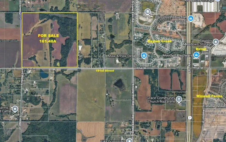
+"LotSizeArea": 161.48
+"LivingArea": 0
+"BuildingAreaTotal": 0
+"City": "Spring Hill"
+"PostalCode": "66083"
+"UnparsedAddress": "Nec 191 Street & Hedge Lane, Spring Hill, Kansas 66083"
+"Coordinates": array:2 [
0 => -94.8507184
1 => 38.78379867
]
+"Latitude": 38.78379867
+"Longitude": -94.8507184
+"YearBuilt": 0
+"InternetAddressDisplayYN": true
+"FeedTypes": "IDX"
+"ListAgentFullName": "Nancy Kirk Matthew"
+"ListOfficeName": "Compass Realty Group"
+"ListAgentMlsId": "NMATTHEW"
+"ListOfficeMlsId": "CMLC"
+"OriginatingSystemName": "HMLS"
+"PublicRemarks": "High Development Location. 1.5 miles to 175th Street and Hedge Lane to the new extra large Amazon warehouse and 1.8 miles to the new Coke manufacturing and distribution center. Large number of job creation in this location. Less than one mile East is Dayton Creek Elementary - approximately 2 miles East is Forest Spring Middle School and Spring Hill High School. Close to 169 Highway, 175th Street and I35. Easy access to Spring Hill, Gardner, Olathe and the Metro area. Great topography. Spring Hill can sewer this property."
+"ActivationDate": "2026-02-10"
+"AssociationFeeFrequency": "None"
+"AttributionContact": "913-244-5480"
+"CoListAgentFullName": "Kirk Matthew"
+"CoListAgentKey": "1056821"
+"CoListAgentMlsId": "KMATTHEW"
+"CoListOfficeKey": "31945716"
+"CoListOfficeMlsId": "CMLC"
+"CoListOfficeName": "Compass Realty Group"
+"CoListOfficePhone": "816-280-2773"
+"CountyOrParish": "Johnson, KS"
+"CreationDate": "2026-02-10T17:53:58.770105+00:00"
+"CurrentUse": array:1 [
0 => "Agricultural"
]
+"DevelopmentStatus": array:1 [
0 => "Raw Land"
]
+"Directions": "169 Highway - 191st Street West to Hedge Lane - property on the NEC -OR- 175th Street to Hedge Lane - Hedge Lane South to 191st Street - property on the NEC"
+"DocumentsAvailable": array:1 [
0 => "Aerial Photos"
]
+"ElementarySchool": "Dayton Creek"
+"HighSchool": "Spring Hill"
+"HighSchoolDistrict": "Spring Hill"
+"RFTransactionType": "For Sale"
+"InternetEntireListingDisplayYN": true
+"ListAgentDirectPhone": "913-244-5480"
+"ListAgentKey": "1051886"
+"ListOfficeKey": "31945716"
+"ListOfficePhone": "816-280-2773"
+"ListingAgreement": "Exclusive Right To Sell"
+"ListingContractDate": "2026-02-10"
+"ListingTerms": "Cash,Conventional"
+"LotFeatures": array:1 [
0 => "Acreage"
]
+"LotSizeSquareFeet": 7034068.8
+"MLSAreaMajor": "370 - N=167th;S=Co Ln;E=Pflumm;W=Clare Rd"
+"MiddleOrJuniorSchool": "Forest Spring"
+"MlgCanUse": array:1 [
0 => "IDX"
]
+"MlgCanView": true
+"MlsStatus": "Active"
+"OtherStructures": array:1 [
0 => "None"
]
+"ParcelNumber": "9F231434-2001"
+"PhotosChangeTimestamp": "2026-02-10T17:53:10Z"
+"PhotosCount": 3
+"PossibleUse": array:2 [
0 => "Agricultural"
1 => "Residential"
]
+"RoadFrontageType": array:1 [
0 => "County Road"
]
+"RoadResponsibility": array:1 [
0 => "Public Maintenance"
]
+"RoadSurfaceType": array:1 [
0 => "Paved"
]
+"Sewer": "Other"
+"StateOrProvince": "KS"
+"StreetName": "191 Street & Hedge"
+"StreetNumber": "NEC"
+"StreetSuffix": "Lane"
+"SubdivisionName": "Other"
+"TaxLegalDescription": "34-14-23 SW 1/4 EX .30 AC IN ST 159.7 ACS M/L SP -0047"
+"Topography": "Level, Rolling"
+"Vegetation": array:1 [
0 => "Crop(s)"
]
+"WaterSource": array:1 [
0 => "Rural"
]
+"Zoning": "AG"
+"HMS_SoilType": "Unknown-Verify"
+"HMS_SaleOptions": "Complete Parcel"
+"HMS_InFloodPlain": "Yes"
+"HMS_TaxTotalAmount": "1471"
+"HMS_AgricultureType": "Grain/Crops"
+"HMS_MineralDescription": "All Rights Included"
+"HMS_BathroomsTotalDecimal": "0.00"
+"HMS_MaintenanceProvidedYN": "0"
+"@odata.id": "https://api.realtyfeed.com/reso/odata/Property('HMS51286899')"
+"provider_name": "HMLS"
+"short_address": "Spring Hill, Kansas 66083, USA"
+"Media": array:3 [
0 => array:11 [
"Order" => 0
"MediaKey" => "698b7057819c870f0a8bd363"
"MediaURL" => "https://cdn.realtyfeed.com/cdn/41/HMS51286899/5c0c71132c454fa30e243c194831f3ce.webp"
"MediaSize" => 87002
"MediaType" => "webp"
"Thumbnail" => "https://cdn.realtyfeed.com/cdn/41/HMS51286899/thumbnail-5c0c71132c454fa30e243c194831f3ce.webp"
"ImageWidth" => 813
"ImageHeight" => 521
"ResourceRecordKey" => "HMS51286899"
"ImageSizeDescription" => "813x521"
"MediaModificationTimestamp" => "2026-02-10T17:52:23.018Z"
]
1 => array:11 [
"Order" => 1
"MediaKey" => "698b7057819c870f0a8bd364"
"MediaURL" => "https://cdn.realtyfeed.com/cdn/41/HMS51286899/3c1e011067c945f3ed4c215d7f501b60.webp"
"MediaSize" => 131002
"MediaType" => "webp"
"Thumbnail" => "https://cdn.realtyfeed.com/cdn/41/HMS51286899/thumbnail-3c1e011067c945f3ed4c215d7f501b60.webp"
"ImageWidth" => 1024
"ImageHeight" => 643
"ResourceRecordKey" => "HMS51286899"
"ImageSizeDescription" => "1024x643"
"MediaModificationTimestamp" => "2026-02-10T17:52:22.972Z"
]
2 => array:11 [
"Order" => 2
"MediaKey" => "698b7057819c870f0a8bd365"
"MediaURL" => "https://cdn.realtyfeed.com/cdn/41/HMS51286899/9db0a6252b8b0130f8f697760b737228.webp"
"MediaSize" => 24179
"MediaType" => "webp"
"Thumbnail" => "https://cdn.realtyfeed.com/cdn/41/HMS51286899/thumbnail-9db0a6252b8b0130f8f697760b737228.webp"
"ImageWidth" => 381
"ImageHeight" => 357
"ResourceRecordKey" => "HMS51286899"
"ImageSizeDescription" => "381x357"
"MediaModificationTimestamp" => "2026-02-10T17:52:22.961Z"
]
]
+"ID": "244416"
}
2 => Realtyna\MlsOnTheFly\Components\CloudPost\SubComponents\RFClient\SDK\RF\Entities\RFProperty {#3914
+post_id: "237408"
+post_author: 1
+"ListingKey": "HMS51083468"
+"ListingId": "2596186"
+"PropertyType": "Land"
+"PropertySubType": "Unimproved Land"
+"StandardStatus": "Pending"
+"ModificationTimestamp": "2026-02-10T17:42:10Z"
+"RFModificationTimestamp": "2026-02-10T17:43:23Z"
+"ListPrice": 14000.0
+"BathroomsTotalInteger": 0
+"BathroomsHalf": 0
+"BedroomsTotal": 0
+"LotSizeArea": 0.55
+"LivingArea": 0
+"BuildingAreaTotal": 0
+"City": "Raytown"
+"PostalCode": "64138"
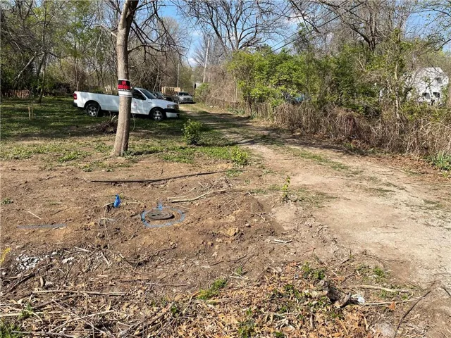
+"UnparsedAddress": "7814 E 86th Street, Raytown, Missouri 64138"
+"Coordinates": array:2 [
0 => -94.495723
1 => 38.968343
]
+"Latitude": 38.968343
+"Longitude": -94.495723
+"YearBuilt": 0
+"InternetAddressDisplayYN": true
+"FeedTypes": "IDX"
+"ListAgentFullName": "Thrive RealEstate KC Team"
+"ListOfficeName": "KW KANSAS CITY METRO"
+"ListAgentMlsId": "THRIVETM"
+"ListOfficeMlsId": "KW04"
+"OriginatingSystemName": "HMLS"
+"PublicRemarks": "Discover an exceptional opportunity at 7814 E?86th Street, Raytown, MO 64138—a spacious 0.55-acre vacant lot ready to fulfill your vision for a beautiful custom-built home or investment property. Tucked away on a quiet residential street, this lot offers the rare combination of size, location, and potential. With plenty of room to build, you can design your dream home, add a garage or workshop, and still enjoy a generous yard for outdoor living. Located in an established neighborhood with mature trees and easy access to schools, parks, shopping, and major highways, this property offers both peace and convenience. Whether you're an owner-occupant looking for the perfect build site or an investor seeking your next opportunity, this parcel delivers. Utilities are available at the street, and the level terrain simplifies site prep—making your build process more efficient and cost-effective. Don’t miss this chance to secure a prime piece of land in a growing Raytown community."
+"ActivationDate": "2026-01-14"
+"AttributionContact": "913-825-7720"
+"CoListAgentFullName": "Franck Brichet"
+"CoListAgentKey": "1074370"
+"CoListAgentMlsId": "413597528"
+"CoListOfficeKey": "1007959"
+"CoListOfficeMlsId": "KW04"
+"CoListOfficeName": "KW KANSAS CITY METRO"
+"CoListOfficePhone": "913-825-7500"
+"CountyOrParish": "Jackson"
+"CreationDate": "2026-01-13T19:46:11.146815+00:00"
+"CurrentUse": array:1 [
0 => "Other"
]
+"Directions": "Blue Ridge Blvd. to 86th street go East on 86th st. house on left"
+"HighSchoolDistrict": "Raytown"
+"RFTransactionType": "For Sale"
+"InternetEntireListingDisplayYN": true
+"ListAgentDirectPhone": "913-825-7720"
+"ListAgentKey": "1070970"
+"ListOfficeKey": "1007959"
+"ListOfficePhone": "913-825-7500"
+"ListingAgreement": "Exclusive Right To Sell"
+"ListingContractDate": "2026-01-13"
+"LotSizeSquareFeet": 23958
+"MLSAreaMajor": "205 - Raytown Area"
+"MlgCanUse": array:1 [
0 => "IDX"
]
+"MlgCanView": true
+"MlsStatus": "Pending"
+"ParcelNumber": "50-320-07-42-00-0-00-000"
+"PhotosChangeTimestamp": "2026-01-20T17:38:10Z"
+"PhotosCount": 9
+"PossibleUse": array:1 [
0 => "Residential"
]
+"StateOrProvince": "MO"
+"StreetDirPrefix": "E"
+"StreetName": "86th"
+"StreetNumber": "7814"
+"StreetSuffix": "Street"
+"SubdivisionName": "Alta Vista Acres"
+"TaxLegalDescription": "ALTA VISTA ACRES LOT 6"
+"WaterSource": array:1 [
0 => "Public"
]
+"HMS_InFloodPlain": "No"
+"HMS_TaxTotalAmount": "593"
+"HMS_BathroomsTotalDecimal": "0.00"
+"@odata.id": "https://api.realtyfeed.com/reso/odata/Property('HMS51083468')"
+"provider_name": "HMLS"
+"Media": array:9 [
0 => array:11 [
"Order" => 0
"MediaKey" => "6966a1bc6abcfe44469fefc8"
"MediaURL" => "https://cdn.realtyfeed.com/cdn/41/HMS51083468/b5ce9b88abe26527df75b1f2a8448ae7.webp"
"MediaSize" => 318472
"MediaType" => "webp"
"Thumbnail" => "https://cdn.realtyfeed.com/cdn/41/HMS51083468/thumbnail-b5ce9b88abe26527df75b1f2a8448ae7.webp"
"ImageWidth" => 1024
"ImageHeight" => 768
"ResourceRecordKey" => "HMS51083468"
"ImageSizeDescription" => "1024x768"
"MediaModificationTimestamp" => "2026-01-13T19:49:16.027Z"
]
1 => array:11 [
"Order" => 1
"MediaKey" => "6966a1bc6abcfe44469fefc9"
"MediaURL" => "https://cdn.realtyfeed.com/cdn/41/HMS51083468/7dbaad4cd5ef15bf8b506fc4bc6bc06e.webp"
"MediaSize" => 321226
"MediaType" => "webp"
"Thumbnail" => "https://cdn.realtyfeed.com/cdn/41/HMS51083468/thumbnail-7dbaad4cd5ef15bf8b506fc4bc6bc06e.webp"
"ImageWidth" => 1024
"ImageHeight" => 768
"ResourceRecordKey" => "HMS51083468"
"ImageSizeDescription" => "1024x768"
"MediaModificationTimestamp" => "2026-01-13T19:49:16.062Z"
]
2 => array:11 [
"Order" => 2
"MediaKey" => "6966a1bc6abcfe44469fefca"
"MediaURL" => "https://cdn.realtyfeed.com/cdn/41/HMS51083468/95791a0d80f227b4822523bcaadb9f6b.webp"
"MediaSize" => 168344
"MediaType" => "webp"
"Thumbnail" => "https://cdn.realtyfeed.com/cdn/41/HMS51083468/thumbnail-95791a0d80f227b4822523bcaadb9f6b.webp"
"ImageWidth" => 576
"ImageHeight" => 768
"ResourceRecordKey" => "HMS51083468"
"ImageSizeDescription" => "576x768"
"MediaModificationTimestamp" => "2026-01-13T19:49:16.044Z"
]
3 => array:11 [
"Order" => 3
"MediaKey" => "6966a1bc6abcfe44469fefcb"
"MediaURL" => "https://cdn.realtyfeed.com/cdn/41/HMS51083468/bfa68f7e2b4dbde4a655c4cae1667500.webp"
"MediaSize" => 142438
"MediaType" => "webp"
"Thumbnail" => "https://cdn.realtyfeed.com/cdn/41/HMS51083468/thumbnail-bfa68f7e2b4dbde4a655c4cae1667500.webp"
"ImageWidth" => 576
"ImageHeight" => 768
"ResourceRecordKey" => "HMS51083468"
"ImageSizeDescription" => "576x768"
"MediaModificationTimestamp" => "2026-01-13T19:49:16.050Z"
]
4 => array:11 [
"Order" => 4
"MediaKey" => "696fbd4d22708f4db3200149"
"MediaURL" => "https://cdn.realtyfeed.com/cdn/41/HMS51083468/9f8a5a17d6df46ffaa76a579703a9aa0.webp"
"MediaSize" => 299944
"MediaType" => "webp"
"Thumbnail" => "https://cdn.realtyfeed.com/cdn/41/HMS51083468/thumbnail-9f8a5a17d6df46ffaa76a579703a9aa0.webp"
"ImageWidth" => 1024
"ImageHeight" => 768
"ResourceRecordKey" => "HMS51083468"
"ImageSizeDescription" => "1024x768"
"MediaModificationTimestamp" => "2026-01-20T17:37:17.913Z"
]
5 => array:11 [
"Order" => 5
"MediaKey" => "696fbd4d22708f4db320014a"
"MediaURL" => "https://cdn.realtyfeed.com/cdn/41/HMS51083468/10fd4febafedf1183563d8a369dd9354.webp"
"MediaSize" => 315110
"MediaType" => "webp"
"Thumbnail" => "https://cdn.realtyfeed.com/cdn/41/HMS51083468/thumbnail-10fd4febafedf1183563d8a369dd9354.webp"
"ImageWidth" => 1024
"ImageHeight" => 768
"ResourceRecordKey" => "HMS51083468"
"ImageSizeDescription" => "1024x768"
"MediaModificationTimestamp" => "2026-01-20T17:37:17.954Z"
]
6 => array:11 [
"Order" => 6
"MediaKey" => "696fbd4d22708f4db320014b"
"MediaURL" => "https://cdn.realtyfeed.com/cdn/41/HMS51083468/4ec397a34c7da4922c7e2ca7e0f5ad7b.webp"
"MediaSize" => 304389
"MediaType" => "webp"
"Thumbnail" => "https://cdn.realtyfeed.com/cdn/41/HMS51083468/thumbnail-4ec397a34c7da4922c7e2ca7e0f5ad7b.webp"
"ImageWidth" => 1024
"ImageHeight" => 768
"ResourceRecordKey" => "HMS51083468"
"ImageSizeDescription" => "1024x768"
"MediaModificationTimestamp" => "2026-01-20T17:37:17.939Z"
]
7 => array:11 [
"Order" => 7
"MediaKey" => "696fbd4d22708f4db320014c"
"MediaURL" => "https://cdn.realtyfeed.com/cdn/41/HMS51083468/e9998882f8a298d102226b788df1d187.webp"
"MediaSize" => 346642
"MediaType" => "webp"
"Thumbnail" => "https://cdn.realtyfeed.com/cdn/41/HMS51083468/thumbnail-e9998882f8a298d102226b788df1d187.webp"
"ImageWidth" => 1024
"ImageHeight" => 768
"ResourceRecordKey" => "HMS51083468"
"ImageSizeDescription" => "1024x768"
"MediaModificationTimestamp" => "2026-01-20T17:37:17.967Z"
]
8 => array:11 [
"Order" => 8
"MediaKey" => "696fbd4d22708f4db320014d"
"MediaURL" => "https://cdn.realtyfeed.com/cdn/41/HMS51083468/ce75b0e93ed1d2b428514685362e0e79.webp"
"MediaSize" => 314169
"MediaType" => "webp"
"Thumbnail" => "https://cdn.realtyfeed.com/cdn/41/HMS51083468/thumbnail-ce75b0e93ed1d2b428514685362e0e79.webp"
"ImageWidth" => 1024
"ImageHeight" => 768
"ResourceRecordKey" => "HMS51083468"
"ImageSizeDescription" => "1024x768"
"MediaModificationTimestamp" => "2026-01-20T17:37:17.953Z"
]
]
+"ID": "237408"
}
3 => Realtyna\MlsOnTheFly\Components\CloudPost\SubComponents\RFClient\SDK\RF\Entities\RFProperty {#3907
+post_id: "194813"
+post_author: 1
+"ListingKey": "HMS50557973"
+"ListingId": "2583590"
+"PropertyType": "Land"
+"PropertySubType": "Unimproved Land"
+"StandardStatus": "Closed"
+"ModificationTimestamp": "2026-02-10T17:38:10Z"
+"RFModificationTimestamp": "2026-02-10T17:43:57Z"
+"ListPrice": 249000.0
+"BathroomsTotalInteger": 0
+"BathroomsHalf": 0
+"BedroomsTotal": 0
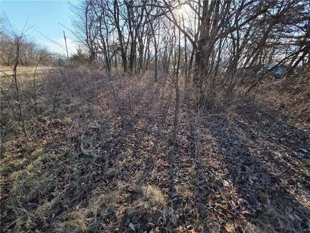
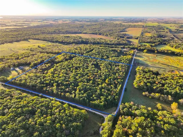
+"LotSizeArea": 45.2
+"LivingArea": 0
+"BuildingAreaTotal": 0
+"City": "Stockton"
+"PostalCode": "65785"
+"UnparsedAddress": "21395 S 725 Road, Stockton, Missouri 65785"
+"Coordinates": array:2 [
0 => -93.946502
1 => 37.589629
]
+"Latitude": 37.589629
+"Longitude": -93.946502
+"YearBuilt": 0
+"InternetAddressDisplayYN": true
+"FeedTypes": "IDX"
+"ListAgentFullName": "James Edwards"
+"ListOfficeName": "United Country Real Estate Buckhorn Land and Realty"
+"ListAgentMlsId": "519500428"
+"ListOfficeMlsId": "UCBLA2"
+"OriginatingSystemName": "HMLS"
+"PublicRemarks": """
Land For Sale Cedar County Mo\r\n
Land for sale located southeast of Jerico Springs, MO. The land consists of 45.26± ac of a mix of healthy red oak and white oak. The property is loaded with deer and turkey. Trails traverse the property making it easy to navigate. There are open areas that would work for bedding or food plot areas.\r\n
\r\n
Land For Sale Stockton MO.\r\n
Located within the Stockton Mo school district is 45.26± ac that would make a great building location. Power is located on the road on 2 sides of the property. While walking the property several whitetail deer were seen along with turkey roosting trees. Rubs and scraps followed the trails through the property, giving several hunting locations.\r\n
\r\n
Recreational Ground For Sale\r\n
Located approx. 15 min from Stockton is a great wooded parcel that offers healthy timber, hunting, camping or home building opportunities. The land is located about an hour from Springfield and Joplin with Kansas City Approx. 2 hrs North.
"""
+"ActivationDate": "2025-10-24"
+"AssociationFeeFrequency": "None"
+"AttributionContact": "417-667-1163"
+"BuyerAgentMlsId": "519500428"
+"BuyerOfficeMlsId": "UCBLA2"
+"CloseDate": "2026-02-10"
+"CountyOrParish": "Cedar"
+"CreationDate": "2025-10-24T18:39:23.447768+00:00"
+"CurrentUse": array:1 [
0 => "Other"
]
+"DevelopmentStatus": array:1 [
0 => "Raw Land"
]
+"Directions": "Drive south from Stockton on Highway 39, turn west onto Y Highway, and then south onto S875 Road. Continue on S875 Road to E 2124 Road, turn west, then turn north onto S 725 Rd, and the property will be on your right. From El Dorado Springs, take US-54 E for about 20 miles to reach Stockton. From there, head south on S 725 Rd, which will become a gravel road. After about 2 miles, the property will be on your left."
+"DocumentsAvailable": array:1 [
0 => "Aerial Photos"
]
+"ElementarySchool": "Stockton"
+"HighSchool": "Stockton"
+"HighSchoolDistrict": "Stockton"
+"RFTransactionType": "For Sale"
+"InternetEntireListingDisplayYN": true
+"ListAgentDirectPhone": "417-667-1163"
+"ListAgentKey": "32162169"
+"ListOfficeKey": "48746974"
+"ListOfficePhone": "(417) 328-8198"
+"ListingAgreement": "Exclusive Agency"
+"ListingContractDate": "2025-10-24"
+"ListingTerms": "Cash,Conventional"
+"LotFeatures": array:2 [
0 => "Acreage"
1 => "Wooded"
]
+"LotSizeSquareFeet": 1968912
+"MLSAreaMajor": "999 - Other Missouri Area"
+"MiddleOrJuniorSchool": "Stockton"
+"MlgCanUse": array:1 [
0 => "IDX"
]
+"MlgCanView": true
+"MlsStatus": "Sold"
+"ParcelNumber": "15-0.4-19-000-000-005.00"
+"PhotosChangeTimestamp": "2025-10-24T18:36:10Z"
+"PhotosCount": 35
+"PossibleUse": array:1 [
0 => "Rural"
]
+"RoadFrontageType": array:1 [
0 => "County Road"
]
+"RoadResponsibility": array:1 [
0 => "Public Maintenance"
]
+"RoadSurfaceType": array:2 [
0 => "Asphalt"
1 => "Gravel"
]
+"Sewer": "None"
+"StateOrProvince": "MO"
+"StreetDirPrefix": "S"
+"StreetName": "725"
+"StreetNumber": "21395"
+"StreetSuffix": "Road"
+"SubdivisionName": "Other"
+"Vegetation": array:2 [
0 => "Natural State"
1 => "Wooded"
]
+"WaterSource": array:1 [
0 => "Other"
]
+"Zoning": "no"
+"HMS_SaleOptions": "Other"
+"HMS_InFloodPlain": "No"
+"HMS_TaxTotalAmount": "27"
+"HMS_AgricultureType": "Other"
+"HMS_BathroomsTotalDecimal": "0.00"
+"HMS_MaintenanceProvidedYN": "0"
+"@odata.id": "https://api.realtyfeed.com/reso/odata/Property('HMS50557973')"
+"provider_name": "HMLS"
+"Media": array:35 [
0 => array:12 [
"Order" => 0
"MediaKey" => "68fbc6ef98d4443c4ed160c1"
"MediaURL" => "https://cdn.realtyfeed.com/cdn/41/HMS50557973/6bbd08d7420b42d466b69b45556bf2c4.webp"
"MediaSize" => 179259
"MediaType" => "webp"
"Thumbnail" => "https://cdn.realtyfeed.com/cdn/41/HMS50557973/thumbnail-6bbd08d7420b42d466b69b45556bf2c4.webp"
"ImageWidth" => 1024
"ImageHeight" => 681
"LongDescription" => "View of road featuring a forest view"
"ResourceRecordKey" => "HMS50557973"
"ImageSizeDescription" => "1024x681"
"MediaModificationTimestamp" => "2025-10-24T18:35:27.088Z"
]
1 => array:12 [
"Order" => 1
"MediaKey" => "68fbc6ef98d4443c4ed160c2"
"MediaURL" => "https://cdn.realtyfeed.com/cdn/41/HMS50557973/55594e7112e6c16762e6002f2894b359.webp"
"MediaSize" => 234289
"MediaType" => "webp"
"Thumbnail" => "https://cdn.realtyfeed.com/cdn/41/HMS50557973/thumbnail-55594e7112e6c16762e6002f2894b359.webp"
"ImageWidth" => 1024
"ImageHeight" => 767
"LongDescription" => "Aerial view of property and surrounding area featuring property boundaries highlighted"
"ResourceRecordKey" => "HMS50557973"
"ImageSizeDescription" => "1024x767"
"MediaModificationTimestamp" => "2025-10-24T18:35:27.088Z"
]
2 => array:12 [
"Order" => 2
"MediaKey" => "68fbc6ef98d4443c4ed160c3"
"MediaURL" => "https://cdn.realtyfeed.com/cdn/41/HMS50557973/395cbe0cb3695300d3afff443b0917ea.webp"
"MediaSize" => 230726
"MediaType" => "webp"
"Thumbnail" => "https://cdn.realtyfeed.com/cdn/41/HMS50557973/thumbnail-395cbe0cb3695300d3afff443b0917ea.webp"
"ImageWidth" => 1024
"ImageHeight" => 767
"LongDescription" => "Bird's eye view of a forest"
"ResourceRecordKey" => "HMS50557973"
"ImageSizeDescription" => "1024x767"
"MediaModificationTimestamp" => "2025-10-24T18:35:27.088Z"
]
3 => array:12 [
"Order" => 3
"MediaKey" => "68fbc6ef98d4443c4ed160c4"
"MediaURL" => "https://cdn.realtyfeed.com/cdn/41/HMS50557973/38acf5d347460f4cbbca8597bb2b16db.webp"
"MediaSize" => 239504
"MediaType" => "webp"
"Thumbnail" => "https://cdn.realtyfeed.com/cdn/41/HMS50557973/thumbnail-38acf5d347460f4cbbca8597bb2b16db.webp"
"ImageWidth" => 1024
"ImageHeight" => 767
"LongDescription" => "View of property location with property boundaries highlighted and a forest"
"ResourceRecordKey" => "HMS50557973"
"ImageSizeDescription" => "1024x767"
"MediaModificationTimestamp" => "2025-10-24T18:35:27.090Z"
]
4 => array:12 [
"Order" => 4
"MediaKey" => "68fbc6ef98d4443c4ed160c5"
"MediaURL" => "https://cdn.realtyfeed.com/cdn/41/HMS50557973/07b848628b340150d61d12f2b37ab7e5.webp"
"MediaSize" => 288754
"MediaType" => "webp"
"Thumbnail" => "https://cdn.realtyfeed.com/cdn/41/HMS50557973/thumbnail-07b848628b340150d61d12f2b37ab7e5.webp"
"ImageWidth" => 1024
"ImageHeight" => 767
"LongDescription" => "View of property location"
"ResourceRecordKey" => "HMS50557973"
"ImageSizeDescription" => "1024x767"
"MediaModificationTimestamp" => "2025-10-24T18:35:27.088Z"
]
5 => array:12 [
"Order" => 5
"MediaKey" => "68fbc6ef98d4443c4ed160c6"
"MediaURL" => "https://cdn.realtyfeed.com/cdn/41/HMS50557973/dc844c2d4c715284e0b04e7767951994.webp"
"MediaSize" => 218406
"MediaType" => "webp"
"Thumbnail" => "https://cdn.realtyfeed.com/cdn/41/HMS50557973/thumbnail-dc844c2d4c715284e0b04e7767951994.webp"
"ImageWidth" => 1024
"ImageHeight" => 767
"LongDescription" => "Aerial overview of property's location with property boundaries highlighted and a heavily wooded area"
"ResourceRecordKey" => "HMS50557973"
"ImageSizeDescription" => "1024x767"
"MediaModificationTimestamp" => "2025-10-24T18:35:27.088Z"
]
6 => array:12 [
"Order" => 6
"MediaKey" => "68fbc6ef98d4443c4ed160c7"
"MediaURL" => "https://cdn.realtyfeed.com/cdn/41/HMS50557973/edffcb8425dc0889c517e98e2df72836.webp"
"MediaSize" => 251287
"MediaType" => "webp"
"Thumbnail" => "https://cdn.realtyfeed.com/cdn/41/HMS50557973/thumbnail-edffcb8425dc0889c517e98e2df72836.webp"
"ImageWidth" => 1024
"ImageHeight" => 767
"LongDescription" => "Aerial view of property and surrounding area featuring a heavily wooded area"
"ResourceRecordKey" => "HMS50557973"
"ImageSizeDescription" => "1024x767"
"MediaModificationTimestamp" => "2025-10-24T18:35:27.088Z"
]
7 => array:12 [
"Order" => 7
"MediaKey" => "68fbc6ef98d4443c4ed160c8"
"MediaURL" => "https://cdn.realtyfeed.com/cdn/41/HMS50557973/a6027b0734a81a70d0a85cf735d9bd87.webp"
"MediaSize" => 289392
"MediaType" => "webp"
"Thumbnail" => "https://cdn.realtyfeed.com/cdn/41/HMS50557973/thumbnail-a6027b0734a81a70d0a85cf735d9bd87.webp"
"ImageWidth" => 1024
"ImageHeight" => 681
"LongDescription" => "View of wooded area"
"ResourceRecordKey" => "HMS50557973"
"ImageSizeDescription" => "1024x681"
"MediaModificationTimestamp" => "2025-10-24T18:35:27.090Z"
]
8 => array:12 [
"Order" => 8
"MediaKey" => "68fbc6ef98d4443c4ed160c9"
"MediaURL" => "https://cdn.realtyfeed.com/cdn/41/HMS50557973/40e32d78e4f0967f0ac66a1fe0a2a889.webp"
"MediaSize" => 247046
"MediaType" => "webp"
"Thumbnail" => "https://cdn.realtyfeed.com/cdn/41/HMS50557973/thumbnail-40e32d78e4f0967f0ac66a1fe0a2a889.webp"
"ImageWidth" => 1024
"ImageHeight" => 681
"LongDescription" => "Exterior view"
"ResourceRecordKey" => "HMS50557973"
"ImageSizeDescription" => "1024x681"
"MediaModificationTimestamp" => "2025-10-24T18:35:27.088Z"
]
9 => array:12 [
"Order" => 9
"MediaKey" => "68fbc6ef98d4443c4ed160ca"
"MediaURL" => "https://cdn.realtyfeed.com/cdn/41/HMS50557973/00a708f53deaa166bc79ae3d0769c929.webp"
"MediaSize" => 254697
"MediaType" => "webp"
"Thumbnail" => "https://cdn.realtyfeed.com/cdn/41/HMS50557973/thumbnail-00a708f53deaa166bc79ae3d0769c929.webp"
"ImageWidth" => 1024
"ImageHeight" => 681
"LongDescription" => "View of local wilderness"
"ResourceRecordKey" => "HMS50557973"
"ImageSizeDescription" => "1024x681"
"MediaModificationTimestamp" => "2025-10-24T18:35:27.088Z"
]
10 => array:12 [
"Order" => 10
"MediaKey" => "68fbc6ef98d4443c4ed160cb"
"MediaURL" => "https://cdn.realtyfeed.com/cdn/41/HMS50557973/82ba7be52c54d4ca6526d6acbed148cd.webp"
"MediaSize" => 166851
"MediaType" => "webp"
"Thumbnail" => "https://cdn.realtyfeed.com/cdn/41/HMS50557973/thumbnail-82ba7be52c54d4ca6526d6acbed148cd.webp"
"ImageWidth" => 1024
"ImageHeight" => 681
"LongDescription" => "View of local wilderness"
"ResourceRecordKey" => "HMS50557973"
"ImageSizeDescription" => "1024x681"
"MediaModificationTimestamp" => "2025-10-24T18:35:27.032Z"
]
11 => array:12 [
"Order" => 11
"MediaKey" => "68fbc6ef98d4443c4ed160cc"
"MediaURL" => "https://cdn.realtyfeed.com/cdn/41/HMS50557973/efa204998a6561a341f2025f679d1952.webp"
"MediaSize" => 220228
"MediaType" => "webp"
"Thumbnail" => "https://cdn.realtyfeed.com/cdn/41/HMS50557973/thumbnail-efa204998a6561a341f2025f679d1952.webp"
"ImageWidth" => 1024
"ImageHeight" => 681
"LongDescription" => "View of nature"
"ResourceRecordKey" => "HMS50557973"
"ImageSizeDescription" => "1024x681"
"MediaModificationTimestamp" => "2025-10-24T18:35:27.029Z"
]
12 => array:12 [
"Order" => 12
"MediaKey" => "68fbc6ef98d4443c4ed160cd"
"MediaURL" => "https://cdn.realtyfeed.com/cdn/41/HMS50557973/1d19c3292d9e723bd9cc5b80157bb7c3.webp"
"MediaSize" => 274764
"MediaType" => "webp"
"Thumbnail" => "https://cdn.realtyfeed.com/cdn/41/HMS50557973/thumbnail-1d19c3292d9e723bd9cc5b80157bb7c3.webp"
"ImageWidth" => 1024
"ImageHeight" => 681
"LongDescription" => "View of woods"
"ResourceRecordKey" => "HMS50557973"
"ImageSizeDescription" => "1024x681"
"MediaModificationTimestamp" => "2025-10-24T18:35:27.088Z"
]
13 => array:12 [
"Order" => 13
"MediaKey" => "68fbc6ef98d4443c4ed160ce"
"MediaURL" => "https://cdn.realtyfeed.com/cdn/41/HMS50557973/65e2cc48da64ab36fb89b475c6c79a91.webp"
"MediaSize" => 274231
"MediaType" => "webp"
"Thumbnail" => "https://cdn.realtyfeed.com/cdn/41/HMS50557973/thumbnail-65e2cc48da64ab36fb89b475c6c79a91.webp"
"ImageWidth" => 1024
"ImageHeight" => 681
"LongDescription" => "View of tree filled area"
"ResourceRecordKey" => "HMS50557973"
"ImageSizeDescription" => "1024x681"
"MediaModificationTimestamp" => "2025-10-24T18:35:27.088Z"
]
14 => array:12 [
"Order" => 14
"MediaKey" => "68fbc6ef98d4443c4ed160cf"
"MediaURL" => "https://cdn.realtyfeed.com/cdn/41/HMS50557973/5428344318f087c7f89e4b5272dd0174.webp"
"MediaSize" => 235891
"MediaType" => "webp"
"Thumbnail" => "https://cdn.realtyfeed.com/cdn/41/HMS50557973/thumbnail-5428344318f087c7f89e4b5272dd0174.webp"
"ImageWidth" => 1024
"ImageHeight" => 681
"LongDescription" => "View of woods"
"ResourceRecordKey" => "HMS50557973"
"ImageSizeDescription" => "1024x681"
"MediaModificationTimestamp" => "2025-10-24T18:35:27.068Z"
]
15 => array:12 [
"Order" => 15
"MediaKey" => "68fbc6ef98d4443c4ed160d0"
"MediaURL" => "https://cdn.realtyfeed.com/cdn/41/HMS50557973/5d49e8a0298b62c93366f90620033e47.webp"
"MediaSize" => 228574
"MediaType" => "webp"
"Thumbnail" => "https://cdn.realtyfeed.com/cdn/41/HMS50557973/thumbnail-5d49e8a0298b62c93366f90620033e47.webp"
"ImageWidth" => 1024
"ImageHeight" => 681
"LongDescription" => "View of local wilderness"
"ResourceRecordKey" => "HMS50557973"
"ImageSizeDescription" => "1024x681"
"MediaModificationTimestamp" => "2025-10-24T18:35:27.032Z"
]
16 => array:12 [
"Order" => 16
"MediaKey" => "68fbc6ef98d4443c4ed160d1"
"MediaURL" => "https://cdn.realtyfeed.com/cdn/41/HMS50557973/479911627c9de8bf1a422e16bd5a9afc.webp"
"MediaSize" => 255365
"MediaType" => "webp"
"Thumbnail" => "https://cdn.realtyfeed.com/cdn/41/HMS50557973/thumbnail-479911627c9de8bf1a422e16bd5a9afc.webp"
"ImageWidth" => 1024
"ImageHeight" => 681
"LongDescription" => "View of wooded area"
"ResourceRecordKey" => "HMS50557973"
"ImageSizeDescription" => "1024x681"
"MediaModificationTimestamp" => "2025-10-24T18:35:27.088Z"
]
17 => array:12 [
"Order" => 17
"MediaKey" => "68fbc6ef98d4443c4ed160d2"
"MediaURL" => "https://cdn.realtyfeed.com/cdn/41/HMS50557973/b846cb2f4dec6383b2e83f79e8a4874e.webp"
"MediaSize" => 271056
"MediaType" => "webp"
"Thumbnail" => "https://cdn.realtyfeed.com/cdn/41/HMS50557973/thumbnail-b846cb2f4dec6383b2e83f79e8a4874e.webp"
"ImageWidth" => 1024
"ImageHeight" => 681
"LongDescription" => "View of wooded area"
"ResourceRecordKey" => "HMS50557973"
"ImageSizeDescription" => "1024x681"
"MediaModificationTimestamp" => "2025-10-24T18:35:27.029Z"
]
18 => array:12 [
"Order" => 18
"MediaKey" => "68fbc6ef98d4443c4ed160d3"
"MediaURL" => "https://cdn.realtyfeed.com/cdn/41/HMS50557973/b49a7e5efd790d5544c373f964a98505.webp"
"MediaSize" => 219958
"MediaType" => "webp"
"Thumbnail" => "https://cdn.realtyfeed.com/cdn/41/HMS50557973/thumbnail-b49a7e5efd790d5544c373f964a98505.webp"
"ImageWidth" => 1024
"ImageHeight" => 681
"LongDescription" => "Exterior view"
"ResourceRecordKey" => "HMS50557973"
"ImageSizeDescription" => "1024x681"
"MediaModificationTimestamp" => "2025-10-24T18:35:27.032Z"
]
19 => array:12 [
"Order" => 19
"MediaKey" => "68fbc6ef98d4443c4ed160d4"
"MediaURL" => "https://cdn.realtyfeed.com/cdn/41/HMS50557973/a3397453a3ac8172cdf997687177f155.webp"
"MediaSize" => 272685
"MediaType" => "webp"
"Thumbnail" => "https://cdn.realtyfeed.com/cdn/41/HMS50557973/thumbnail-a3397453a3ac8172cdf997687177f155.webp"
"ImageWidth" => 1024
"ImageHeight" => 681
"LongDescription" => "View of woods"
"ResourceRecordKey" => "HMS50557973"
"ImageSizeDescription" => "1024x681"
"MediaModificationTimestamp" => "2025-10-24T18:35:27.029Z"
]
20 => array:12 [
"Order" => 20
"MediaKey" => "68fbc6ef98d4443c4ed160d5"
"MediaURL" => "https://cdn.realtyfeed.com/cdn/41/HMS50557973/670f2044b866d7a15b3994f26dd910c5.webp"
"MediaSize" => 262740
"MediaType" => "webp"
"Thumbnail" => "https://cdn.realtyfeed.com/cdn/41/HMS50557973/thumbnail-670f2044b866d7a15b3994f26dd910c5.webp"
"ImageWidth" => 1024
"ImageHeight" => 681
"LongDescription" => "View of wooded area"
"ResourceRecordKey" => "HMS50557973"
"ImageSizeDescription" => "1024x681"
"MediaModificationTimestamp" => "2025-10-24T18:35:27.088Z"
]
21 => array:12 [
"Order" => 21
"MediaKey" => "68fbc6ef98d4443c4ed160d6"
"MediaURL" => "https://cdn.realtyfeed.com/cdn/41/HMS50557973/dc415e5bb3b9f009e11f9e8c7a4eb5ba.webp"
"MediaSize" => 261512
"MediaType" => "webp"
"Thumbnail" => "https://cdn.realtyfeed.com/cdn/41/HMS50557973/thumbnail-dc415e5bb3b9f009e11f9e8c7a4eb5ba.webp"
"ImageWidth" => 1024
"ImageHeight" => 681
"LongDescription" => "View of woods"
"ResourceRecordKey" => "HMS50557973"
"ImageSizeDescription" => "1024x681"
"MediaModificationTimestamp" => "2025-10-24T18:35:27.088Z"
]
22 => array:12 [
"Order" => 22
"MediaKey" => "68fbc6ef98d4443c4ed160d7"
"MediaURL" => "https://cdn.realtyfeed.com/cdn/41/HMS50557973/f22cd1e09aff0124c089c71ce9ce54e6.webp"
"MediaSize" => 293293
"MediaType" => "webp"
"Thumbnail" => "https://cdn.realtyfeed.com/cdn/41/HMS50557973/thumbnail-f22cd1e09aff0124c089c71ce9ce54e6.webp"
"ImageWidth" => 1024
"ImageHeight" => 681
"LongDescription" => "View of local wilderness"
"ResourceRecordKey" => "HMS50557973"
"ImageSizeDescription" => "1024x681"
"MediaModificationTimestamp" => "2025-10-24T18:35:27.069Z"
]
23 => array:12 [
"Order" => 23
"MediaKey" => "68fbc6ef98d4443c4ed160d8"
"MediaURL" => "https://cdn.realtyfeed.com/cdn/41/HMS50557973/72515e1794bf4bef982d750cb068f4e8.webp"
"MediaSize" => 229584
"MediaType" => "webp"
"Thumbnail" => "https://cdn.realtyfeed.com/cdn/41/HMS50557973/thumbnail-72515e1794bf4bef982d750cb068f4e8.webp"
"ImageWidth" => 1024
"ImageHeight" => 681
"LongDescription" => "View of woods"
"ResourceRecordKey" => "HMS50557973"
"ImageSizeDescription" => "1024x681"
"MediaModificationTimestamp" => "2025-10-24T18:35:27.029Z"
]
24 => array:12 [
"Order" => 24
"MediaKey" => "68fbc6ef98d4443c4ed160d9"
"MediaURL" => "https://cdn.realtyfeed.com/cdn/41/HMS50557973/a21a340f511c80dd3a71354e36ee36b8.webp"
"MediaSize" => 242079
"MediaType" => "webp"
"Thumbnail" => "https://cdn.realtyfeed.com/cdn/41/HMS50557973/thumbnail-a21a340f511c80dd3a71354e36ee36b8.webp"
"ImageWidth" => 1024
"ImageHeight" => 681
"LongDescription" => "View of undeveloped land"
"ResourceRecordKey" => "HMS50557973"
"ImageSizeDescription" => "1024x681"
"MediaModificationTimestamp" => "2025-10-24T18:35:27.018Z"
]
25 => array:12 [
"Order" => 25
"MediaKey" => "68fbc6ef98d4443c4ed160da"
"MediaURL" => "https://cdn.realtyfeed.com/cdn/41/HMS50557973/e946cdc3fd310bb53bf4bad7d5c72184.webp"
"MediaSize" => 227294
"MediaType" => "webp"
"Thumbnail" => "https://cdn.realtyfeed.com/cdn/41/HMS50557973/thumbnail-e946cdc3fd310bb53bf4bad7d5c72184.webp"
"ImageWidth" => 1024
"ImageHeight" => 681
"LongDescription" => "Exterior view"
"ResourceRecordKey" => "HMS50557973"
"ImageSizeDescription" => "1024x681"
"MediaModificationTimestamp" => "2025-10-24T18:35:27.032Z"
]
26 => array:12 [
"Order" => 26
"MediaKey" => "68fbc6ef98d4443c4ed160db"
"MediaURL" => "https://cdn.realtyfeed.com/cdn/41/HMS50557973/0d252d710e280fc54cf1449401935870.webp"
"MediaSize" => 209146
"MediaType" => "webp"
"Thumbnail" => "https://cdn.realtyfeed.com/cdn/41/HMS50557973/thumbnail-0d252d710e280fc54cf1449401935870.webp"
"ImageWidth" => 1024
"ImageHeight" => 681
"LongDescription" => "Exterior view"
"ResourceRecordKey" => "HMS50557973"
"ImageSizeDescription" => "1024x681"
"MediaModificationTimestamp" => "2025-10-24T18:35:27.029Z"
]
27 => array:12 [
"Order" => 27
"MediaKey" => "68fbc6ef98d4443c4ed160dc"
"MediaURL" => "https://cdn.realtyfeed.com/cdn/41/HMS50557973/7f1d9b8cb5eed4141132412e05d1fd4d.webp"
"MediaSize" => 265123
"MediaType" => "webp"
"Thumbnail" => "https://cdn.realtyfeed.com/cdn/41/HMS50557973/thumbnail-7f1d9b8cb5eed4141132412e05d1fd4d.webp"
"ImageWidth" => 1024
"ImageHeight" => 681
"LongDescription" => "View of wooded area"
"ResourceRecordKey" => "HMS50557973"
"ImageSizeDescription" => "1024x681"
"MediaModificationTimestamp" => "2025-10-24T18:35:27.018Z"
]
28 => array:12 [
"Order" => 28
"MediaKey" => "68fbc6ef98d4443c4ed160dd"
"MediaURL" => "https://cdn.realtyfeed.com/cdn/41/HMS50557973/f06e9ba6e075884d4cee9be41fb93e34.webp"
"MediaSize" => 136687
"MediaType" => "webp"
"Thumbnail" => "https://cdn.realtyfeed.com/cdn/41/HMS50557973/thumbnail-f06e9ba6e075884d4cee9be41fb93e34.webp"
"ImageWidth" => 1024
"ImageHeight" => 681
"LongDescription" => "View of local wilderness"
"ResourceRecordKey" => "HMS50557973"
"ImageSizeDescription" => "1024x681"
"MediaModificationTimestamp" => "2025-10-24T18:35:27.088Z"
]
29 => array:12 [
"Order" => 29
"MediaKey" => "68fbc6ef98d4443c4ed160de"
"MediaURL" => "https://cdn.realtyfeed.com/cdn/41/HMS50557973/5b2dc84afec0ec57de477fdab521790f.webp"
"MediaSize" => 178725
"MediaType" => "webp"
"Thumbnail" => "https://cdn.realtyfeed.com/cdn/41/HMS50557973/thumbnail-5b2dc84afec0ec57de477fdab521790f.webp"
"ImageWidth" => 1024
"ImageHeight" => 681
"LongDescription" => "View of undeveloped land"
"ResourceRecordKey" => "HMS50557973"
"ImageSizeDescription" => "1024x681"
"MediaModificationTimestamp" => "2025-10-24T18:35:27.029Z"
]
30 => array:12 [
"Order" => 30
"MediaKey" => "68fbc6ef98d4443c4ed160df"
"MediaURL" => "https://cdn.realtyfeed.com/cdn/41/HMS50557973/9310df25997c77a973111614add8d148.webp"
"MediaSize" => 255593
"MediaType" => "webp"
"Thumbnail" => "https://cdn.realtyfeed.com/cdn/41/HMS50557973/thumbnail-9310df25997c77a973111614add8d148.webp"
"ImageWidth" => 1024
"ImageHeight" => 681
"LongDescription" => "Exterior view"
"ResourceRecordKey" => "HMS50557973"
"ImageSizeDescription" => "1024x681"
"MediaModificationTimestamp" => "2025-10-24T18:35:27.018Z"
]
31 => array:12 [
"Order" => 31
"MediaKey" => "68fbc6ef98d4443c4ed160e0"
"MediaURL" => "https://cdn.realtyfeed.com/cdn/41/HMS50557973/3f06d2e2d33f804a0ae6f84630947c88.webp"
"MediaSize" => 274547
"MediaType" => "webp"
"Thumbnail" => "https://cdn.realtyfeed.com/cdn/41/HMS50557973/thumbnail-3f06d2e2d33f804a0ae6f84630947c88.webp"
"ImageWidth" => 1024
"ImageHeight" => 681
"LongDescription" => "View of wooded area"
"ResourceRecordKey" => "HMS50557973"
"ImageSizeDescription" => "1024x681"
"MediaModificationTimestamp" => "2025-10-24T18:35:27.029Z"
]
32 => array:12 [
"Order" => 32
"MediaKey" => "68fbc6ef98d4443c4ed160e1"
"MediaURL" => "https://cdn.realtyfeed.com/cdn/41/HMS50557973/71d6e7f4dcfcd1190f352960f7eef4d2.webp"
"MediaSize" => 221016
"MediaType" => "webp"
"Thumbnail" => "https://cdn.realtyfeed.com/cdn/41/HMS50557973/thumbnail-71d6e7f4dcfcd1190f352960f7eef4d2.webp"
"ImageWidth" => 1024
"ImageHeight" => 681
"LongDescription" => "View of undeveloped land"
"ResourceRecordKey" => "HMS50557973"
"ImageSizeDescription" => "1024x681"
"MediaModificationTimestamp" => "2025-10-24T18:35:27.090Z"
]
33 => array:12 [
"Order" => 33
"MediaKey" => "68fbc6ef98d4443c4ed160e2"
"MediaURL" => "https://cdn.realtyfeed.com/cdn/41/HMS50557973/45d219fff1158baaad403daf798a3746.webp"
"MediaSize" => 146471
"MediaType" => "webp"
"Thumbnail" => "https://cdn.realtyfeed.com/cdn/41/HMS50557973/thumbnail-45d219fff1158baaad403daf798a3746.webp"
"ImageWidth" => 1024
"ImageHeight" => 681
"LongDescription" => "Exterior view"
"ResourceRecordKey" => "HMS50557973"
"ImageSizeDescription" => "1024x681"
"MediaModificationTimestamp" => "2025-10-24T18:35:27.088Z"
]
34 => array:12 [
"Order" => 34
"MediaKey" => "68fbc6ef98d4443c4ed160e3"
"MediaURL" => "https://cdn.realtyfeed.com/cdn/41/HMS50557973/a9e59e8e48c4ff8dd6228450e46048f6.webp"
"MediaSize" => 210267
"MediaType" => "webp"
"Thumbnail" => "https://cdn.realtyfeed.com/cdn/41/HMS50557973/thumbnail-a9e59e8e48c4ff8dd6228450e46048f6.webp"
"ImageWidth" => 1024
"ImageHeight" => 681
"LongDescription" => "Exterior view"
"ResourceRecordKey" => "HMS50557973"
"ImageSizeDescription" => "1024x681"
"MediaModificationTimestamp" => "2025-10-24T18:35:27.123Z"
]
]
+"ID": "194813"
}
]
+success: true
+page_size: 4
+page_count: 1432
+count: 5727
+after_key: ""
}
"RF Response Time" => "0.18 seconds"
]
]

")